Forest structure and its changes from multi-temporallidar data: a homogeneously derived database forpeninsular Spain
DOI:
https://doi.org/10.15287/afr.2026.4341Abstract
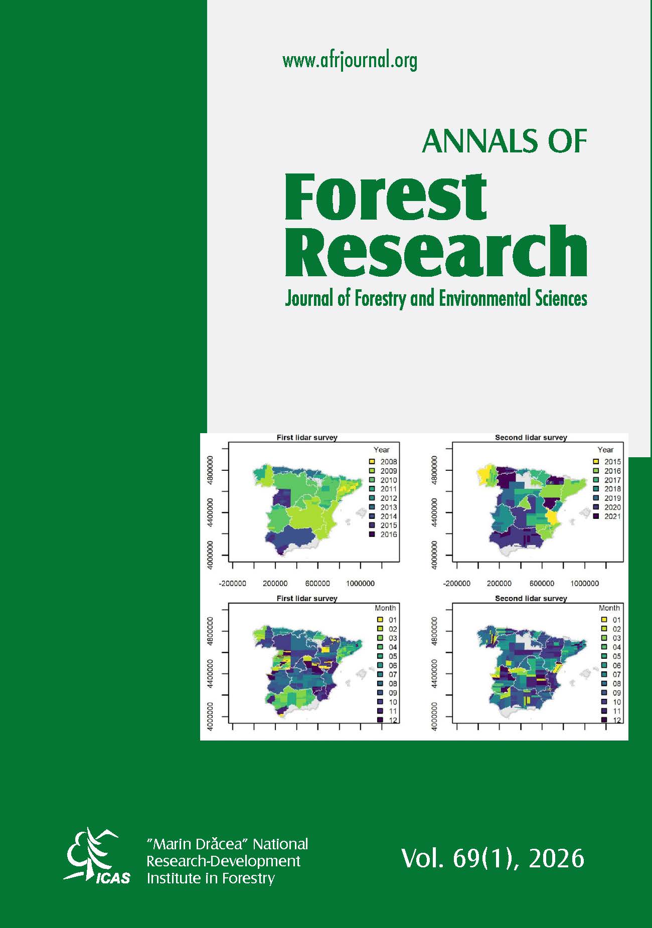
Monitoring forest structure across large and heterogeneous landscapes is essential to understanding ecosystem dynamics, carbon stocks, and the impacts of global change. This study leverages lidar surveys from Spain's national airborne laser scanning (ALS) program to produce harmonized, high-resolution maps of canopy height, canopy cover, and aboveground biomass (AGB) across peninsular Spain over two periods: 2008-2016 and 2015-2021. We developed a consistent processing workflow to overcome challenges posed by heterogeneous lidar acquisitions, and integrate the resulting metrics with National Forest Inventory (NFI) data to model AGB using machine learning algorithms. Validation against field data demonstrated high accuracy for canopy height (R² > 0.8; RMSE < 3 m in some regions) and acceptable performance for AGB estimation (RMSE: 23–44 t ha⁻¹). Between the two lidar surveys, forests exhibited structural development in forest canopies, with average annual increases of 0.2 m in height and 0.9% in canopy cover, particularly pronounced in the Atlantic regions. Species-level analysis highlighted the structural and functional contrast between biomes: high-biomass Atlantic species such as Fagus sylvatica and Pinus radiata reached up to 188 t ha⁻¹ and 126 t ha⁻¹ AGB, respectively, while Mediterranean species like Quercus ilex and P. halepensis remained under 35 t ha⁻¹. Comparisons with global and regional satellite-derived products revealed that airborne lidar offers superior spatial detail and accuracy, especially in structurally complex forests. ALS-based height estimates showed significantly lower mean absolute error (MAE: 1.6–3.7 m) than global products (MAE: 2.9–7.8 m), and the GEDI dataset consistently overestimated canopy height, 5.9 m on average, across the peninsular Spain. This work highlights the critical role of harmonized lidar datasets for robust forest monitoring, and provides a valuable baseline for future ecological assessments, carbon accounting, and validation of satellite products across the peninsular Spain.
References
Blanco Castro E., Costa Tenorio M., Morla Juaristi C., Sáinz Ollero H., 2005. Los bosques ibéricos: una interpretación geobotánica. Planeta, Barcelona.
Blondel J. & Aronson J., 1995. Biodiversity and Ecosystem Function in the Mediterranean Basin: Human and Non-Human Determinants. In: Davis G.W. & Richardson D.M. (Eds.), Mediterranean-Type Ecosystems: The Function of Biodiversity. Springer Berlin Heidelberg, Berlin, Heidelberg, pp. 43-119.
Bombín R.V., 2005. El Mapa Forestal de España escala 1:50.000 (MFE50) como base del Tercer Inventario Forestal Nacional. Cuadernos de la Sociedad Española de Ciencias Forestales 19, 205-210.
Bonan G.B., 2016. Forests, Climate, and Public Policy: A 500-Year Interdisciplinary Odyssey. Annual Review of Ecology, Evolution, and Systematics 47, 97-121. https://doi.org/10.1146/annurev-ecolsys-121415-032359.
Breiman, L., 2001. Random Forests. Machine Learning 45, 5-32. https://doi.org/10.1023/A:1010933404324.
Bright B.C., Hudak A.T., McCarley T.R., Spannuth A., Sánchez-López N., Ottmar R.D., Soja A.J., 2022. Multitemporal lidar captures heterogeneity in fuel loads and consumption on the Kaibab Plateau. Fire Ecology 18, 18. https://doi.org/10.1186/s42408-022-00142-7.
Buotte P.C., Law B.E., Ripple W.J., Berner L.T., 2020. Carbon sequestration and biodiversity co-benefits of preserving forests in the western United States. Ecological Applications 30, e02039. https://doi.org/10.1002/eap.2039.
Coops N.C., Tompalski P., Goodbody T.R.H., Queinnec M., Luther J.E., Bolton D.K., White J.C., Wulder M.A., van Lier O.R., Hermosilla T., 2021. Modelling lidar-derived estimates of forest attributes over space and time: A review of approaches and future trends. RSEnv 260, 112477. https://doi.org/10.1016/j.rse.2021.112477
Delgado-Artés R., Garófano‐Gómez V., Oliver-Villanueva J.-V., Rojas-Briales E., 2022. Land Use/Cover Change Analysis in the Mediterranean Region: A Regional Case Study of Forest Evolution in Castelló (Spain) Over 50 Years. Land Use Policy 114, 105967. https://doi.org/10.1016/j.landusepol.2021.105967.
Dorado-Roda I., Pascual A., Godinho S., Silva C.A., Botequim B., Rodríguez-Gonzálvez P., González-Ferreiro E., Guerra-Hernández J., 2021. Assessing the Accuracy of GEDI Data for Canopy Height and Aboveground Biomass Estimates in Mediterranean Forests. Remote Sensing, 13(12), 2279; https://doi.org/10.3390/rs13122279.
Dubayah R., Blair J.B., Goetz S., Fatoyinbo L., Hansen M., Healey S., Hofton M., Hurtt G., Kellner J., Luthcke S., Armston J., Tang H., Duncanson L., Hancock S., Jantz P., Marselis S., Patterson P.L., Qi W., Silva C., 2020. The Global Ecosystem Dynamics Investigation: High-resolution laser ranging of the Earth’s forests and topography. Science of Remote Sensing 1, 100002. https://doi.org/10.1016/j.srs.2020.100002.
EUROSTAT, 2022. Land cover statistics – Land Use and Cover Area frame Survey (LUCAS). In. European Commission, European Union.
Evans J.S. & Hudak A.T., 2007. A multiscale curvature algorithm for classifying discrete return LiDAR in forested environments. ITGRS 45, 1029-1038.
Fassnacht F.E., Latifi H., Stereńczak K., Modzelewska A., Lefsky M., Waser L.T., Straub C., Ghosh A., 2016. Review of studies on tree species classification from remotely sensed data. RSEnv 186, 64-87. https://doi.org/10.1016/j.rse.2016.08.013.
Freund Y. & Schapire R.E., 1997. A Decision-Theoretic Generalization of On-Line Learning and an Application to Boosting. JCoSS 55, 119-139. https://doi.org/10.1006/jcss.1997.1504.
Friedman J.H., 2001. Greedy function approximation: A gradient boosting machine. The Annals of Statistics 29, 1189-1232. https://doi.org/10.1214/aos/1013203451
Henttonen H.M. & Kangas A., 2015. Optimal plot design in a multipurpose forest inventory. Forest Ecosystems 2, 31. https://doi.org/10.1186/s40663-015-0055-2.
Houghton R.A. & Byers B., Nassikas A.A., 2015. A role for tropical forests in stabilizing atmospheric CO2. Nature Climate Change 5, 1022-1023. https://doi.org/10.1038/nclimate2869.
Hudak A.T., Fekety P.A., Kane V.R., Kennedy R.E., Filippelli S.K., Falkowski M.J., Tinkham W.T., Smith A.M.S., Crookston N.L., Domke G.M., Corrao M.V., Bright B.C., Churchill D.J., Gould P.J., McGaughey R.J., Kane J.T., Dong J., 2020. A carbon monitoring system for mapping regional, annual aboveground biomass across the northwestern USA. Environ. Res. Let. 15, 095003. https://doi.org/10.1088/1748-9326/ab93f9.
Lang N., Jetz W., Schindler K., Wegner J.D., 2023. A high-resolution canopy height model of the Earth. Nature Ecology & Evolution 7, 1778-1789. https://doi.org/10.1038/s41559-023-02206-6.
Lines E.R., Zavala M.A., Purves D.W., Coomes D.A., 2012. Predictable changes in aboveground allometry of trees along gradients of temperature, aridity and competition. Global Ecology and Biogeography 21, 1017-1028. https://doi.org/10.1111/j.1466-8238.2011.00746.x.
Matasci G., Hermosilla T., Wulder M.A., White J.C., Coops N.C., Hobart G.W., Zald H.S.J., 2018. Large-area mapping of Canadian boreal forest cover, height, biomass and other structural attributes using Landsat composites and lidar plots. RSEnv 209, 90-106. https://doi.org/10.1016/j.rse.2017.12.020.
Mauro F., Ritchie M., Wing B., Frank B., Monleon V., Temesgen H., Hudak A., 2019. Estimation of Changes of Forest Structural Attributes at Three Different Spatial Aggregation Levels in Northern California using Multitemporal LiDAR. Remote Sensing, 11(8), 923. https://doi.org/10.3390/rs11080923.
McCarley T.R., Kolden C.A., Vaillant N.M., Hudak A.T., Smith A.M.S., Wing B.M., Kellogg B.S., Kreitler J., 2017. Multi-temporal LiDAR and Landsat quantification of fire-induced changes to forest structure. RSEnv 191, 419-432. https://doi.org/10.1016/j.rse.2016.12.022.
Montero G., Ruiz-Peinado R., Muñoz M., 2005. Produccion de biomasas y fijacion de CO2 por los bosques españoles. Ministerio de Ciencia y Tecnologia, Madrid.
Pan Y., McCullough K., Hollinger D.Y., 2018. Forest biodiversity, relationships to structural and functional attributes, and stability in New England forests. Forest Ecosystems 5, 14. https://doi.org/10.1186/s40663-018-0132-4.
Potapov P., Li X., Hernandez-Serna A., Tyukavina A., Hansen M.C., Kommareddy A., Pickens A., Turubanova S., Tang H., Silva C.E., Armston J., Dubayah R., Blair J.B., Hofton M., 2021. Mapping global forest canopy height through integration of GEDI and Landsat data. RSEnv 253, 112165. https://doi.org/10.1016/j.rse.2020.112165.
Ruiz-Benito P., Gómez-Aparicio L., Paquette A., Messier C., Kattge J., Zavala M.A., 2014. Diversity increases carbon storage and tree productivity in Spanish forests. Global Ecology and Biogeography 23, 311-322. https://doi.org/10.1111/geb.12126 .
San-Miguel-Ayanz J., Durrant T., Boca R., Maianti P., Liberta G., Oom D., Branco A., De Rigo D., Ferrari D., Roglia E. and Scionti N., 2023. Advance Report on Forest Fires in Europe, Middle East and North Africa 2022. In, Luxembourg. https://doi.org/10.2760/091540.
Sanz V. & Soto V.D., 1990. Segundo Inventario Forestal Nacional 1986-1995 Explicaciones y metodos. EGRAF S.A., Madrid.
Senf C. & Seidl R., 2020. Mapping the forest disturbance regimes of Europe. Nature Sustainability 4, 63-70. https://doi.org/10.1038/s41893-020-00609-y.
Senf C., Seidl R., Hostert P., 2017. Remote sensing of forest insect disturbances: current state and future directions. IJAEO, 60, 49-60. https://doi.org/10.1016/j.jag.2017.04.004.
Su Y., Schwartz M., Fayad I., García M., Zavala M.A., Tijerín-Triviño J., Astigarraga J., Cruz-Alonso V., Liu S., Zhang X., Chen S., Ritter F., Besic N., d’Aspremont A., Ciais P., 2025. Canopy height and biomass distribution across the forests of Iberian Peninsula. Scientific Data 12, 678. https://doi.org/10.1038/s41597-025-05021-9.
Tanase M., Martini J.P., Miranda P., Garcia D., Wilke V., Miguel S., Mihai C., Diez J., Natal S., Martin D.S., Astigarraga J., Ruiz-Benito P., 2026. Long-term forest structure trends in the peninsular Spain from lidar-optical sensors synergies. RSEnv 334. https://doi.org/10.1016/j.rse.2025.115196.
Tolan J., Yang H.-I., Nosarzewski B., Couairon G., Vo H.V., Brandt J., Spore J., Majumdar S., Haziza D., Vamaraju J., Moutakanni T., Bojanowski P., Johns T., White B., Tiecke T., Couprie C., 2024. Very high resolution canopy height maps from RGB imagery using self-supervised vision transformer and convolutional decoder trained on aerial lidar. RSEnv 300, 113888. https://doi.org/10.1016/j.rse.2023.113888.
Tomppo E., Schadauer K., McRoberts R.E., Gschwantner T., Gabler K., Ståhl G., 2010. Introduction. In: Tomppo, T.G., Lawrence M., McRoberts R. E. (Ed.), National Forest Inventories: Pathways for Common Reporting. Springer, New York, p. 614.
van Ewijk K.Y., Treitz P.M., Scott N.A., 2011. Characterizing Forest Succession in Central Ontario using Lidar-derived Indices. Photogrammetric Engineering & Remote Sensing 77, 261-269. https://doi.org/10.14358/PERS.77.3.261.
van Rees E., 2013. Rapidlasso: Efficient Tools for LiDAR Processing. GeoInformatics 16, 14-16.
Villaescusa R. & Díaz R., 1998. Segundo Inventario Forestal Nacional (1986-1996). In. Ministerio de Medio Ambiente, ICONA, Madrid, p. 337.
White J.C., Coops N.C., Wulder M.A., Vastaranta M., Hilker T., Tompalski P., 2016. Remote Sensing Technologies for Enhancing Forest Inventories: A Review. Canadian Journal of Remote Sensing 42, 619-641. https://doi.org/10.1080/07038992.2016.1207484.
Wulder M.A., Hermosilla T., Stinson G., Gougeon F.A., White J.C., Hill D.A., Smiley B.P., 2020. Satellite-based time series land cover and change information to map forest area consistent with national and international reporting requirements. Forestry: An International Journal of Forest Research 93, 331-343. https://doi.org/10.1093/forestry/cpaa006.
Downloads
Published
Issue
Section
License
All the papers published in Annals of Forest Research are available under an open access policy (Gratis Gold Open Access Licence), which guaranty the free (of taxes) and unlimited access, for anyone, to entire content of the all published articles. The users are free to "read, copy, distribute, print, search or refers to the full text of these articles", as long they mention the source.
The other materials (texts, images, graphical elements presented on the Website) are protected by copyright.
The journal exerts a permanent quality check, based on an established protocol for publishing the manuscripts. The potential article to be published are evaluated (peer-review) by members of the Editorial Board or other collaborators with competences on the paper topics. The publishing of manuscript is free of charge, all the costs being supported by Forest Research and Management Institute.
More details about Open Access:
Wikipedia: http://en.wikipedia.org/wiki/Open_access