The use of remote sensing indices derived from Sentinel 2 satellite images for the defoliation damage assessment of Lymantria dispar
DOI:
https://doi.org/10.15287/afr.2023.3013Abstract
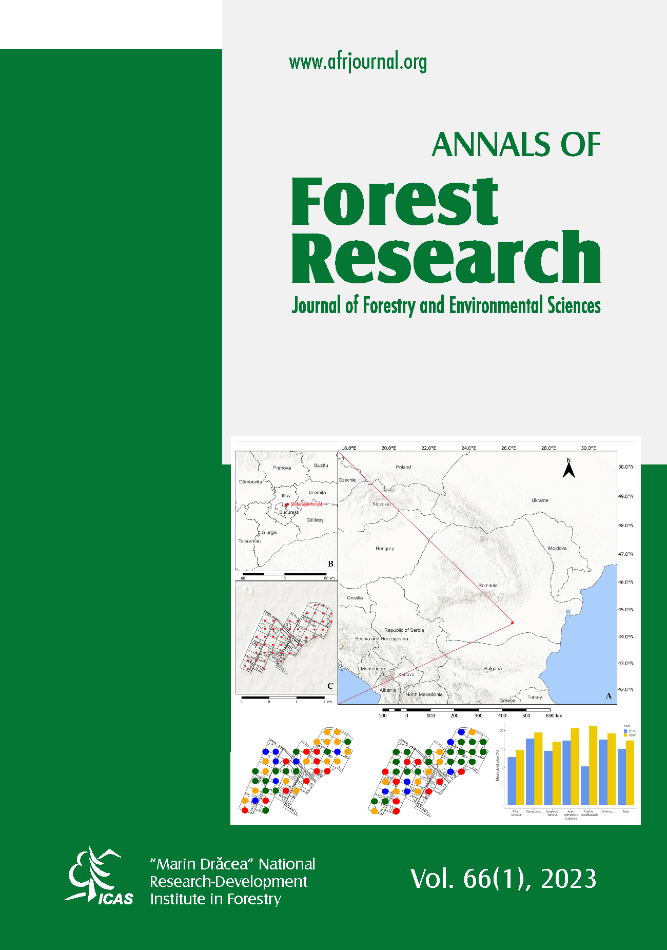
Monitoring and assessing the phytosanitary status of forests is a crucial activity in forest protection field, and the use of satellite remote sensing has become increasingly prevalent in this regard. Satellite images offer valuable information in terms of time and space, particularly through the analysis of vegetation and biophysical indices. Within this context, the aim of the study was to explore the potential of satellite remote sensing methods to monitor and assess the extent of tree defoliation caused by the gypsy moth (Lymantria dispar). The research study was focused on a forest situated in the Oltenia region of Romania, which experienced a gradation period for the defoliator L. dispar between 2018 and 2020. To determine the extent of defoliation caused by L. dispar in 2020 and 2021, a rectangular network consisting of 70 one-hectare sample areas was implemented. Each sample area had a square shape with a side of 100 m. In each corner of the sample areas, sub-sample circles with a radius of 12.62 meters were established, in which visual observations regarding the defoliation levels were conducted. The study involved a comparison between thematic maps derived from ground observations and those based on specific remote sensing indices derived through the processing of Sentinel 2 satellite images, of the Ciuturica forest area during the years 2020 and 2021. The research study indicated that the canopy water content (CWC) index was the most suitable for assessing defoliation caused by L. dispar. Furthermore, the study highlighted that remote sensing methods could be very effective and easily applicable, complementing the field ground-based efforts in monitoring and assessing the impact of L. dispar infestations.
Downloads
Published
Issue
Section
License
All the papers published in Annals of Forest Research are available under an open access policy (Gratis Gold Open Access Licence), which guaranty the free (of taxes) and unlimited access, for anyone, to entire content of the all published articles. The users are free to "read, copy, distribute, print, search or refers to the full text of these articles", as long they mention the source.
The other materials (texts, images, graphical elements presented on the Website) are protected by copyright.
The journal exerts a permanent quality check, based on an established protocol for publishing the manuscripts. The potential article to be published are evaluated (peer-review) by members of the Editorial Board or other collaborators with competences on the paper topics. The publishing of manuscript is free of charge, all the costs being supported by Forest Research and Management Institute.
More details about Open Access:
Wikipedia: http://en.wikipedia.org/wiki/Open_access